Search

Showing posts with label Abby Wilson. Show all posts

Friday, August 23, 2024

‘Lost River’ temporarily flows again in Windham after 100 years

By Abby Wilson

When a dam malfunction resulted in the emptying of Dundee Pond at the start of the summer, a lost river took its place.

Whitney Falls has reappeared in Windham as part of the 
'Lost River,' a portion of the Presumpscot River which was 
swallowed up when a dam was built creating Dundee Pond
more than 100 years ago. The 'Lost River' returned this
summer when a dam gate malfunction drained Dundee Pond.
PHOTO BY ABBY WILSON  
Located in Windham and flowing past Dundee Park, this “lost river” is part of the Presumpscot River.

Recently the Friends of the Presumpscot River, whose mission is to protect and restore the waterway, held a series of guided walks for the public along the river called “The River That Flows Below: A Presumpscot River Walk & Talk.”

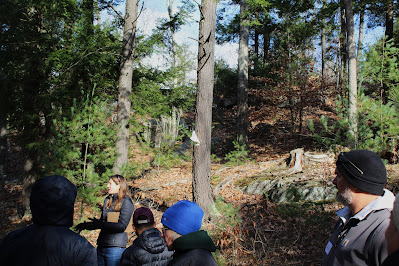
On Sunday, Aug. 18, both Rob Sanford, a Professor Emeritus for the University of Southern Maine’s Environmental Science Department and Michael Shaughnessy, a founding member and the President of the Friends of the Presumpscot River, explored the lost river landscape with more than 50 community residents.

"The town didn't know this was going to happen," said Shaughnessy. “The disappearance of the pond came as a total shock to everyone, but the formation of this river and what was revealed below, even more so.

Sanford who is also the author of “Reading the Rural Landscape” and the editor of “River Voices: Perspectives on the Presumpscot River,” said that the stumps along the path of the river are 110 to 120 years old.

He is skilled in understanding the story and history of a landscape. Standing at Dundee Park and looking out over the lost river, it was difficult not to notice its dramatic features.

This area of the river was the site of an original canal project dating back to the late 1700s. During this time, many dams were being built along the Presumpscot River for hydroelectricity. The pond was not flooded until 1910, however, which means the last time this landscape featured a river was over 100 years ago.

The former pond’s stark delineation and water line is a very dramatic feature. But it’s the tree stumps and fissured soil that resembles a different planet, or perhaps our planet but in an apocalyptic time.

In the flat areas where the stumps were scarce, Sandford said that these would have been fields filled with grazing sheep. During the time before the area was flooded, sheep would have been valuable commodities.

“In the Civil War a lot of wool for uniforms came from New England,” said Sanford.

A “wolf tree” stump was spotted in a clearing on top of a knoll. Such a large tree would have been where farmers rested with their horses.

Much of the dry soil in the area is gray “Presumpscot Clay,” which was in demand many years ago when Gorham had eight different brickmakers.

In minutes, the features of the landscape can be recognized by the human eye, but Shaughnessy questions the environmental impacts created by the dam malfunction.

"A lot of environmental remediation is going to need to happen here," said Shaughnessy.

He pointed out that the freshwater mussels scattered underfoot were at one time living in the benthic zone of the pond, filtering and cleaning the water.

The color green is returning to the landscape, however, and life can be seen all around. Small flowers and grasses are pioneering their way into the bare landscape.

A Great Blue Heron was spotted in the distance. It triggers the memory of birds that once thrived among the shores of this river.

Presumpscot is the Wabanaki word for “many rough places” and prior to colonization, the river may have featured up to 18 waterfalls. Only three falls are now visible including Presumpscot Falls in Falmouth, Saccarappa Falls in Westbrook, and Wescot Falls near North Gorham Pond.

In the rapids of this 100-year-old river near Dundee Park, “Whitney’s Falls” have reappeared and are now the fourth set of modern-day waterfalls in the area.

This name dates back to a time when fish such as salmon, trout, eels and herring dominated the river. Bear, otters, eagles, and osprey flocked here to claim these fish as their meal.

“This is a unique and historic moment," said Shaughnessy. "The Presumpscot River at Dundee has been dammed for well over 100 years. For the first, and possibly last time, a wild river with vibrant rapids and falls is revealed. In addition, the historic lands, eerily barren, cracked and shorn, but so well preserved, are likewise momentarily seen again. What is revealed is indicative of what lays under many of this river's still waters."

The company that manages the dam that malfunctioned unveiling the “lost river,” Relevate Power Management, has estimated that dam repairs will be completed by the end of August and the impoundment will be refilled thereafter, thus reforming Dundee Pond.

Meanwhile, take a walk back in time through this small valley and visualize a landscape that’s more than a century old.

On Sunday, Aug. 25, Friends of the Presumpscot River will be hosting another informational walk along the "Lost River." Meet at Dundee Park at 3 p.m. and the public is welcome to attend.

To learn more, visit the Friends of the Presumpscot River website at www.presumpscotriver.org <

Friday, March 31, 2023

Hopkins Dam key to erosion prevention on Little Sebago Lake

By Abby Wilson

Little Sebago Lake has many special features, including an outlet dam that regulates the water level to mitigate erosion and prevent lakeside property damage. Hopkins Dam is owned by the Little Sebago Lake Association and Rod Bernier has managed the dam since 1996.

Hopkins Dam was built on Little Sebago
Lake in 1890 and continues to regulate
water levels on the lake to prevent erosion
and mitigate water damage to lakeside
properties. PHOTO BY STAN PAUWELS  
As the dam keeper there, his basic role is to operate and maintain the dam, says Bernier, and his regular duties include checking water level and regulating outflow.

Hopkins Dam is an outlet dam, so Bernier pays careful attention to the water level because the state mandates that the lake be kept at a certain level from April 15 to October 15.

The dam keeper must also develop emergency plans with the state and Cumberland County Soil and Water Conservation District in case the dam fails.

The last time a dam failed on Little Sebago Lake was in 1861.

“After a period of heavy rain, it washed out everything between here and the ocean,” says Bernier. There were reports of the Presumpscot River flowing backwards due to flooding.

A new dam was built in 1890, and Bernier says it has “certainly stood and held to the test of time.”

The Hopkins Dam was purchased by the Little Sebago Lake Association in 1952 from the S.D. Warren Paper Mill for $2,500 plus $400 to cover surveying costs.

As a 501(c)(3) nonprofit, Little Sebago Lake Association can receive funding through donations. Memberships are not required from residents but annual donations have been able to cover most expenses including operation of the dam and water quality testing.

The association tests for water clarity and oxygen and with the help of students at Saint Joseph’s College, they also test for chlorophyll and phosphorous.

Lake Association President, Pam Wilkinson, says “membership has been great.” In fact, last year the gate mechanism needed an upgrade and $76,000 was raised. Lake side residents contributed largely to this project, as well as the towns of Gray and Windham.

This gate mechanism is very important for regulating the water level of the dam but is also key in allowing fish to pass through. There are no salmon species in Little Sebago Lake, so the dam does not have migrating fish, however, year-round, a small area (about 4 inches) is left open for freshwater fish to exit and go downstream.

There is a gauge installed on the face of the dam and Bernier must watch this gauge very closely. Ideally, the gauge remains at 0 during the summer. As of March 14, the gauge measured 19 inches below 0.

In the later winter months, water levels should be low to account for spring rain and snowmelt. Keeping the water level low in winter will prevent flooding and “preserve the shoreline so the ice doesn’t compromise it,” says Wilkinson. When ice melts, it tears the shoreline up as it retreats. This causes erosion of the banks and destruction of property.

The lake association has noticed changes due to climate change. When there is less spring rain or snowmelt and more summer droughts, it results in a low lake level and a higher water temperature. Also, sunlight reaches lower and plants grow where they shouldn’t.

A low lake level affects recreation. As the lake lowers, more bottom-dwelling glacially formed rocks are exposed and are often hit by boat propellers.

Wilkinson said, “Some summers residents tell me ‘that rock grew.’”

Bernier says that as dam keeper he gets many requests.

“People ask me to let water in and open the dam,” he said.

This is of course not possible since Hopkins Dam is an outlet dam and it only can let water out.

It can be tricky to predict these seasonal rain and snow events.

To account for climate change, it seems the dam could just let less water out but Bernier says, “We can’t take the chance with flooding and the number one concern is safety of people downflow, so even if summer levels are low, we can’t take the risk.”

The Little Sebago Lake Association’s mission is “To protect, restore, and improve our lake’s water quality and fragile ecosystem.” The lakeside residents are a huge help in this effort and Bernier says Little Sebago is a “beautiful lake and great community.” Wilkinson speaks of a large rock that many people enjoy jumping into the water from and says “It’s a right-of-passage.”

When Wilkinson asks for volunteers and donations for projects or just general support for the 30 miles of shoreline they manage, the people of Little Sebago Lake show that they care.

“The Little Sebago Lake community is such a special community. We do have people that are concerned and support us,” she said. “This is the way it should be. We have a mission and we hold true to that.”

To learn more about the Hopkins Dam and the Little Sebago Lake Association, visit littlesebagolake.com.<

Friday, December 9, 2022

East Windham Conservation Project advances to next phase

By Abby Wilson

With plans to open in 2023, the East Windham Conservation Project promises to be one of the largest recreational conservation lands in the Greater Portland area.

Rachelle Curran Apse, executive director of the Presumpscot 
Regional Land Trust, talks about the new East Windham
Conservation Project while giving a guided tour of the site
in November. The site is expected to open next year.
PHOTO BY ABBY WILSON
Access to this property will be off Falmouth Road. The parking lot will have enough space for 60 cars and will feature a turnaround area for school buses.

Currently, a woods road runs through the property which will serve as a base for a paved ADA accessible trail. This trail will accommodate wheelchairs and strollers, opening the property up for visitors of all abilities.

This project has been supported by both the Presumpscot Regional Land Trust and the Town of Windham.

Several ‘sneak peek walk-throughs’ for the public have been coordinated. The last event in November brought more than 70 people to the property. A guided hike was led by the land trust and the town, with narration from Rachelle Curran Apse, PRLT Executive Director.

She spoke about the incredible qualities of the East Windham Conservation Project property including views of Mount Washington and the lack of invasive species which she said was “unique and delightful.” Minimal invasive species treatments will be needed in the future which will save staff the need to budget for this type of stewardship.

Curran Apse also said that the property has received necessary funding not only from grants but also individuals in the community. With 70-plus people showing up for early property visits, it’s clear that there is excitement for this project in the Greater Portland Area.

The project will promote accessibility but will also allow for other types of recreation besides walking. The trails will be open to bikes, horses, dogs and skiing. The property will be open for school groups to study nature and for families to get outside and explore. Curran Apse said that kids will be able to learn how to ride a bike on the easy trail system.

By next fall, there will be five miles of trails on the East Windham Conservation Project property. Trails will be completed in part by the Maine Conservation Corps, and by local trail builder Chris Cyr.

He is a resident of Gorham and has built multi-use trails for snowshoeing, hiking and biking. Cyr says that he plans to create green for easy, and blue for medium difficulty trails, with two miles of the five miles planned to be easy walking paths.

Future trail work will include creating an additional five miles with connections to the Town of Windham’s recreational properties. Another project within the next five years will be building an observation tower at the site to provide 360-degree mountain views.

Once the property is open next year, visitors will be able to view Mount Washington, the southern Presidential range, Pleasant Mountain and the White Mountains. This incredible mountain skyscape can be seen after only a third of a mile walk from the parking area.

The property also features spectacular views of Little Duck Pond. The land trust will protect 1,500 feet of pond frontage on top of the existing 38 acres of wetlands, increasing water quality and wildlife habitat.

Access to the pond will be from a short spur trail off the ADA trail. There will not be a put-in for watercraft as the pond is not ideal for swimming because of its shallowness and muddy bottom.

The previous owner had a small quarry on the site which is planned to become an observation area to study geology.

Most of this property is forested and was harvested within the last few years. Curran Apse said that there may be future plans to manage the forest for wildlife habitat but there is no need to support the project financially by harvesting and selling timber.

The East Windham Conservation Project is extremely significant because it will be easily accessible and within a dozen miles from 200,000 people in the state of Maine.

The property will connect to several other conservation areas such as Lowell Preserve, North Falmouth Community Forest and Blackstrap Hill Preserve. Curran Apse said that wildlife and people are expected to benefit from this project.

The property is 750 acres, making it the same size as Bradbury State Park. That state park currently has about 30 miles of trails, while the East Windham Conservation Project plans to create 10 miles of trails. That means this parcel will have ample space and habitat for wildlife to raise young but also to use as a migration corridor. <

Thursday, November 10, 2022

Reports of wildlife sightings increase locally this fall

By Abby Wilson

Migratory animals have left for southern destinations, but Maine wildlife that doesn’t migrate are hunkering down for the winter.

When we think about hibernation, one animal that comes to mind is the black bear. While bears can lower their body temperatures and slow down their metabolism, they are not technically true hibernators.

A rash of black bear sightings in Windham over the past
month may be the result of bears foraging for food sources
such as bird feeders before the onset of winter. 
PHOTO BY ABBY WILSON 
A true hibernator, such as a ground squirrel, will drastically lower all bodily processes such as metabolism and blood pressure. These smaller animals begin hibernation and do not come out until they know there will be adequate resources.

If there is a winter thaw, or a den is flooded by snowmelt, bears may actually wake up, and leave their dens to look for food.

In fact, Scott Lindsay, Regional Biologist at the Gray headquarters for the Maine Department of Inland Fisheries and Wildlife, says it is not unlikely to see bear footprints in the snow.

In preparation for winter sleep, also called torpor, bears must dramatically increase their caloric intake. This can lead to a pulse of wildlife contact reports. In Maine, most of these reports involve black bears, and more often than not, the incident also involves a bird feeder.

Bears need to get the most calories in the most efficient way. They roam uplands and lowlands to forage for food. When a bear finds an introduced food source such as garbage or bird seed, they are going to utilize it because food with high amounts of calories like this are very difficult to find in the wild.

It is best to wait until late November to hang out bird feeders to avoid these incidents. Feeders should then be taken down by April 1, says Lindsay.

Bears are typically in their dens from November to April. In the spring, food resources are once again plentiful, so bears begin to forage on wild foods. They will also use human-introduced resources to supplement their diet.

In fact, Lindsay says that the most wildlife contact in populated areas like Windham and Raymond occur in the spring simply because there are so many animals. Adults are providing resources for babies and there is more consumption of prey as well as more foraging. But once the natural growing season begins there are more wild foods. Wildlife conflict and general wildlife complaints will then drop off.

Lindsay said that when we talk about wildlife populations, we use the term carrying capacity. This is the total number of individuals an ecosystem can handle based on space and resources. There is both a cultural carrying capacity and an ecological carrying capacity. It is important to remember that what you see in your background does not necessarily reflect the number of individuals in the ecosystem as a whole.

Bats are another animal that Maine Inland Fisheries and Wildlife frequently get reports about. Some of the bats we have in Maine are migratory, while others hibernate. Hibernating bats may decide to overwinter in your attic or barn. Professionals known as animal damage control agents can attempt to relocate these bat colonies.

Fall is the proper season to deal with bat related conflicts. If migratory bats are monopolizing a barn or attic, it is best to wait until they leave in the fall. All entry ways can then be covered so that bats will not find their way back into the structure. Do not shut out bats during the summer months because it is the crucial pupping season.

During these times of conflict, as long as an animal is not showing aggression or injuries, a person should secure all food and domestic animals, and leave the animal alone. Lindsay says it’s important to resist temptation to engage in wildlife physically.

There have been situations where people try to domesticate animals such as raccoons by interacting with them and feeding them. This promotes food habituation and conditioning which will ultimately increase wildlife conflict.

“Enjoy watching them, but you should not be encouraging them to be closer,” Lindsay said.

Climate change has greatly affected migration patterns of animals in Maine. The ‘shoulder’ seasons are getting longer, like fall and spring, which is shortening winter. According to the climate science department at the University of Maine, the state has lost 10 days of winter in the last decade.

However, animals are resilient and able to adapt. For example, opossums used to have a more central range in the United States. Today, they exist in southern/central Maine and are popular to see in the Sebago Lake area.

Lindsay says that what’s potentially even more interesting is the increase in human population in Maine. Many people have moved to Maine from urban areas where wildlife was not as common to see in your background. This leads to more frequent conflicts and complaints. Education is an important tool to teach people about how to enjoy wildlife but also how to stay safe around wild animals. <

Friday, October 21, 2022

Migratory birds exiting region for winter habitats

By Abby Wilson

In the last month, you may have noticed birds moving in groups or all together disappearing from the Lakes Region landscape.

Many migratory birds such as the Tree Swallow are
leaving the Lakes Region and Southern Maine this month
and headed south for the winter months. Many species
of migratory birds will return to Maine in the spring.
PHOTO BY ABBY WILSON
We all know what causes this. Migration is an annual event, surprising none of us each year. Animals all over the world move from one place to another to find better food or breeding resources. Many birds are exiting New England to seek favorable winter habitats. For some, this means heading south, toward warmer climates, windy offshore zones in open ocean waters are just the place that calls home.

Maine, and especially the Sebago Lake Region, is a spectacular place to view such migrations and many people spend hours searching for migrating birds in the sky, coastal habitat, and stopover sites (places where birds rest during tiresome migration). This is often a time to see birds that don’t live in Maine but that pass through from winter to summer habitats and vice versa.

“The songbirds we see migrating through Maine right now are coming down from the boreal forests to our north and will move into the southern United States, Caribbean, Mexico, Central America and some even to South America,” says Brad Woodward of Scarborough, an avid birder. “These birds are ultimately looking for better food sources since they have learned over generations that food can be scarce during North American winters.

He also says that the shorebirds on our coast are making astonishing journeys from their breeding grounds on the tundra above the Arctic Circle to wintering grounds as far as the tip of South America.

Some birds migrate thousands of miles each year. The animal with the longest migration in the world is the Arctic Tern which travels from pole to pole (Greenland to Antarctica) several times during its lifetime.

And birds need stopover sites to refuel during the journey.

According to Woodward, Maine is a vital stop for [birds] to feed and rest along the way.

“We will see them all in the spring in a more urgent movement north, needing to get to their breeding grounds in time to find mates, establish territories, nest and raise babies, all in the short summer season in the north before cold approaches and it's time to begin the cycle all over again,” he said.

In southern Maine in mid-October, one might see several songbirds including Gray Catbirds, Northern

Cardinal, Black-capped Chickadees, White-throated Sparrows, and Blue Jays. These birds are typically seen hopping among the understory or flitting from branch to branch in the canopies. Downy and Hairy Woodpeckers are often running up the trunks of trees and haphazardly pecking bark in search of insects. Train your eyes to search the skies as well, and you will notice other birds such as Crows, Canada Geese, and many birds of prey.

Many trained birders identify perhaps more than half of birds by ear, rather than by sight. It takes a lot of practice to notice that each call is distinguishable. Many people can identify the “cheeseburger” mating call of a chickadee, but it takes real skill to know that the Red-tailed hawk territory call coming from the canopy is actually a bluffing Blue Jay.

It is also important to remember that birds are not the only ones making a racket. Frogs, crickets, and chipmunks, all make noise for similar ways. Chipmunks alert others of an intruder, while insects and amphibians send out mating calls.

While walking along a woods trail, birders’ eyes and ears are keen to pick up characteristics that can help them separate one species from another. More often than not an avid birder can recognize an individual with confidence, but sometimes a birder can be taken aback by a rare species.

Some of us remember the Great Black Hawk that appeared in Maine a few years ago and eventually finalized its journey in Portland. Or perhaps the most recent spotting of a Eurasian species, the Stellar’s Sea Eagle, rings a bell. These two individuals are similar in that they are not native to the Eastern U.S. These birds are called vagrants and they appear far outside of their normal breeding, migrating, and feeding ranges for what is often a totally unknown reason.

Vagrants and native migrators visit stopover sites such as waterways, marshes, fields, and even backyards. It is important to keep these areas clean, clear, and safe. If you have a field near your house, or a water source, your property may be a stopover site. Make sure your large windows are not a collision risk by using reflective stickers and decals. If you have a house cat, keep it indoors. Birds face many perils during migration, and we can minimize some of these hazards and make their journey easier. <